Last week I wrote about the famous 11-mile tangent on the CR&NW Railway mentioned by Alfred O. Quinn in his book Iron Rails to Alaskan Copper: The Epic Triumph of Erastus Corning Hawkins.
The tangent ran from Mile 5 to Mile 16, and Quinn mentioned: “Plenty of gravel was available and the tracks were laid on this glacial outwash 3- to 5-feet above the surface of the ground. Construction was relatively easy, and the track crews made good progress.”
Much of the gravel came from a huge pit established at the base of the avalanche zone at 4.5 Mile, where it was loaded on construction train cars to be deposited as the railway was gradually extended to the east.
Quinn did not realize that his description perhaps foreshadowed a future problem when the railway would be converted to a narrow one-lane gravel road immediately after the end of WWII.

Three to five feet above the level of the Delta put the top of the road about eyeball to eyeball with trumpeter swan standing nearby. Which might be fine if it didn’t rain, snow or blow; but those common Copper River Delta events raised havoc with road maintenance.
In the late 1940s and early ’50s, driving to Mile 13 on a skinny pot-holed gravel road atop the railway bed was an adventure worthy of Disneyland. The excitement started at Mile 5. Planks were laid atop the narrow Eyak River railroad bridge to accommodate vehicles, and from the back of our family’s old Ford stave truck, us kids would lean out the sides to see nothing but water when we drove across.
Vehicles had to take turns waiting to cross, and I chuckle every time I see signs on today’s two-lane bridge that warn: “Narrow Bridge.”
The road itself featured turnouts every mile or so, where cars could turn off to let others pass. Nowadays most folks don’t realize that is the purpose of turnouts on the Alaganik Landing road.
But it’s biggest flaw was the road’s elevation. In the winter, winds howling down from Scott Glacier would create snow drifts that quickly filled the road between berms created by snow plows.

Bob Korn ran a taxi service, and one time when taking our family out to catch a DC-3 flight to Anchorage, I remember him laughing as he ran into a snow drift in a whiteout, chasing up a flock of ptarmigan in the process.
Engineers finally figured out how to use the winds to advantage, elevating the road grade so gusts would blow the snow off the top. Today, the highway gradually climbs beginning at Mile 8, with the surface now 10 feet above ground level from Mile 9 to Mile 13.
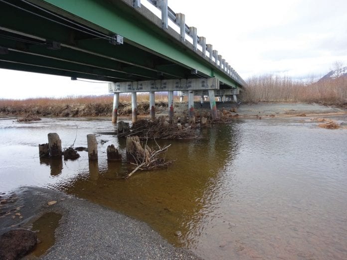
This elevation became obvious while walking up and down the sides of the road on Spring Cleanup, and also led to a historical discovery under the last bridge just prior to the airport. Some trash had blown beneath the concrete and steel span, and lo and behold, there were four sets of pilings under the structure. The very height of the first two rows of old wood piling lent proof to how low the railroad and original road grade were, as they barely cleared the surface of the river.

Nearby, buried in the sand, was testimony to a clever engineering design that ended up succumbing to unanticipated forces — the stub end of a three-sided rail piling. In the late ’50s, when the wooden bridges were being replaced, CR&NW rails, which were stacked in abundance further out the road, were welded together in threesomes to support the bridges.
Alas, with all the weight of the cement bridges atop them shifting dramatically in the 1964 earthquake, many of these railway piling sheared or bent like spaghetti noodles and had to be replaced when the highway was repaired.
The bridges are now supported by large diameter cylindrical steel piling, with a river of history flowing around remnants of days gone by underneath their girder beams.
And I still wish I had been around to ride from Cordova to Kennicott on that amazing Copper River and Northwestern Railway before it, too, became history.

Dick Shellhorn photo/The Cordova Times


