Union Army Generals Phil Sheridan and William Sherman were known for their aggressive tactics during the Civil War and retreat never seemed to enter their minds. They emerged as leaders in battles that eventually ended that bloody and tragic conflict.
Ironically, two glaciers near Cordova that are named in their honor are now retreating — in a pace that is startling and historic.
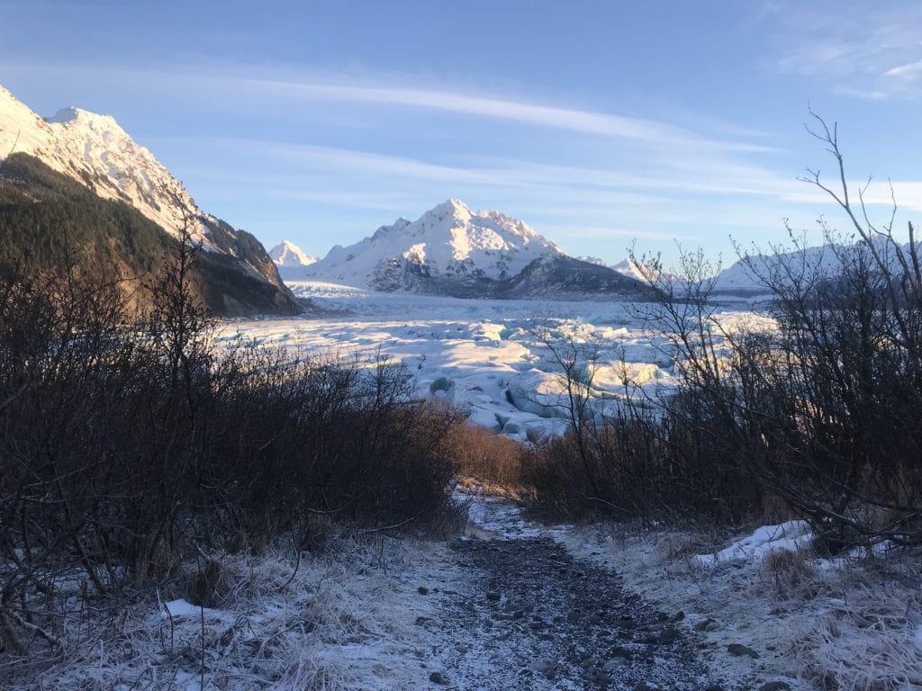
Just beyond the end of U.S. Forest Service Sheridan Glacier Road, which branches off the Copper River Highway at Mile 14, Sheridan and Sherman Glaciers are melting and diminishing in size before our very eyes.
Skeptics of global warming might consider taking periodical hikes down the two-mile trail to Sheridan Lake. They will discover a lake filled with icebergs that advance and vanish on a weekly basis, with the main face of Sheridan Glacier becoming further and further away with every visit.
Many of the glaciers near Cordova were named by U.S. Army Lt. William Abercrombie, who made an unsuccessful attempt to travel all the way up the Copper River in the spring and summer of 1884. On June 21 of that year, he had observed a large glacier 10 miles broad, reaching out from mountains 20 miles away, and called it Sheridan Glacier in honor of Lt. General Phillip H. Sheridan, commanding general of the U.S. Army at that time.
Abercrombie made it to rapids eight miles beyond the eventual site of the Million Dollar Bridge on the Copper River and Northwestern Railway before turning back. It was he who named the two glaciers at Mile 52 Childs, in honor of George Washington Childs of Philadelphia, and Miles, in honor of U.S. Army Brigadier General Nelson Miles, who had authorized his expedition.

Yet Abercrombie did not name Sherman Glacier. That was done in 1910 by Lawrence Martin of the U.S. Geological Survey. Perhaps Abercrombie, from far distance, did not recognize the two distinct side-by-side glaciers when passing by.
Regarding his choice of name, Martin’s notes stated that Sherman had said “war is hell,” so I put him on ice, near the Sheridan Glacier.”
Sherman Glacier became somewhat of a geologist’s delight in 1964, when a huge rockslide from the side of a nearby mountain covered much of the ice field as a result of the Good Friday Earthquake that year. Much of the debris has been gradually moving downward since then, and the lower portion of that glacier is now totally covered in rock.
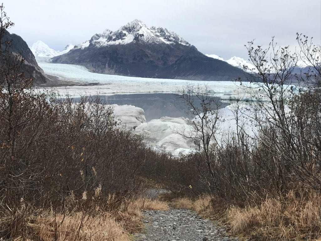
Reports of changes in the pair of glaciers are mainly anecdotal. The USFS does not keep records of its advances or retreats. As late as the early ’50s, Sheridan’s ice extended almost to the beginning of today’s Sheridan Lake Trail.
Sheridan Lake itself is 400 feet deep in places, and for a number of years rafters rowed across the lake and then went through white-water rapids at its outflow to finish a tour at the Sheridan River Bridge at Mile 15 on the highway.
Perhaps no one has noted the changes more than locals who delight in ice skating, biking or hiking amongst ice bergs on Sheridan Lake’s frozen surfaces in the winter. Pressure ridges and occasional tumbling of these large chunks of ice are constant reminders of glacial activity.
For years, the goal of many cross-ice explorers has been to reach the face of Sherman Glacier, which has required a three-mile expedition between ice bergs on the lower edge of Sheridan Lake, before turning north beyond the head of the Sheridan River exit, skirting a timbered island, and finding pristine ice in the uppermost areas.
Such efforts may no longer be required.
On Nov. 5, standing on a ridge above the Sheridan Lake Trail, a clear, straight line along the receding face of the glacier all the way to that very spot was visible.
At the current rate of retreat, it is very likely that a large pond near the start of the trail that is separated from Sheridan Lake by ice and moraine will soon be connected.
If so, Cordovan Guido Casiano, longtime explorer of Sheridan Lake’s ice, will win more than a few bets with his prediction that the pond and lake would eventually become one.
It is also possible that geologist Lawrence Martin’s joke about putting Sherman on ice to cool him off will eventually no longer have meaning.


 268")