This December, Mark Heidbrink learned that his front yard was not actually his front yard. Surveying errors committed more than 40 years ago have left residents’ properties slicing through a public right of way along Whitshed Road. Now, a new construction project by the Department of Transportation & Public Facilities has brought these errors to light.
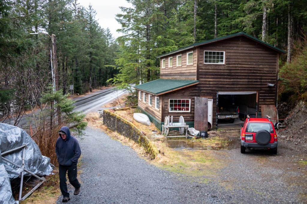
When he built a two-story workshop in his yard, Heidbrink followed a plat, or survey map, approved by the state and the city. The workshop and its surrounding concrete retaining wall fall inside what the plat defined as Heidbrink’s property. However, it has now emerged that part of the wall, as well as part of a small pole barn elsewhere on the property, encroach upon the Whitshed Road right of way. Now, Heidbrink may have to buy part of his own yard back to keep the wall and pole barn intact. Roughly 10 percent of Heidbrink’s 1.93-acre property is seemingly in jeopardy, he said.
“The bitter fact is that I might have to pay for my land twice,” Heidbrink said. “Who do I get to sue about that? The city says, ‘It’s not our fault we gave you an inaccurate plat.’ Well, why isn’t it your fault? … I didn’t do anything irresponsible, and yet I’m possibly going to pay a pretty painful price for it. It’s not right.”
Heidbrink and another Whitshed Road property owner have discussed the possibility of hiring a lawyer to assist in negotiations with the DOT, Heidbrink said.
The federal government acquired the Whitshed Road right of way in 1935, during an era when property lines were not measured as carefully as they are today. Subdivisions were developed along the road from the late ’60s through the ’70s. It was during this period that surveyors made inaccurate measurements of the right of way, said Russell Johnson, highway design engineering manager for the DOT. The surveyors measured on the assumption that the paved road was centered in its right of way, which it was not. Exacerbating this was the fact that the road had moved over time. In some areas, the road itself leaves the right of way. Surveying errors of this kind are rare, Johnson said.
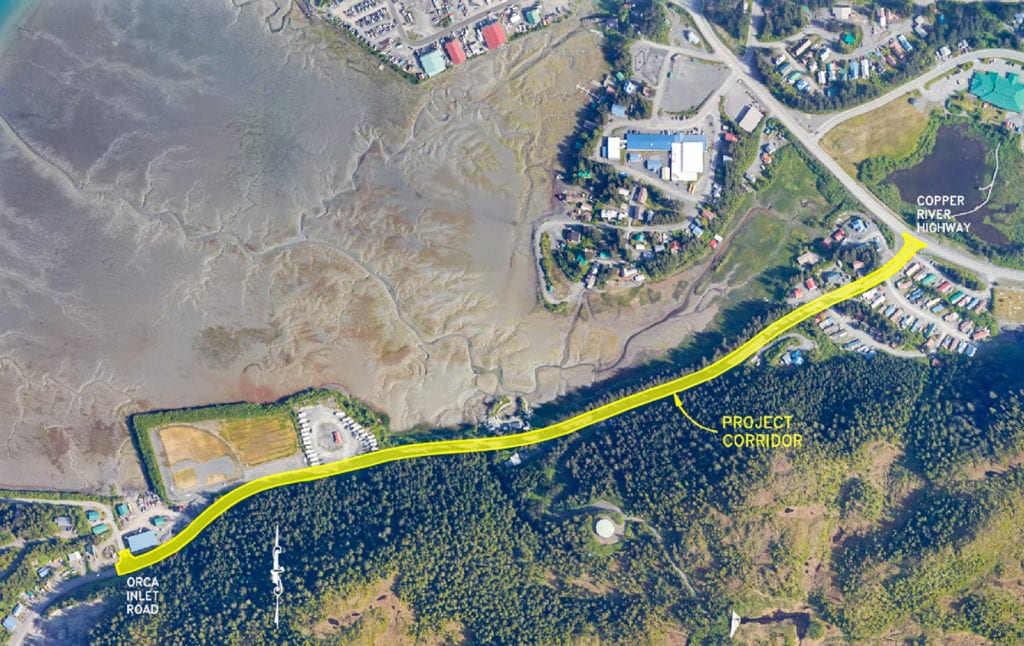
Now, the DOT plans to build a pedestrian path along a 0.8-mile stretch of Whitshed Road. The 8-foot-wide path, separated from the roadway by a 5-foot-wide buffer, would offer pedestrians and cyclists a safer way to travel through the area.

“This project revealed the right of way issues that exist,” Johnson said. “These errors were created before the project started.”
Construction for the project is budgeted at $7.5 million, said Johnson, who is engineering manager for the project. Ninety-one percent of the project’s funding will be provided by the federal government, with the state of Alaska providing 4.5 percent and the city of Cordova and Native Village of Eyak splitting contribution of the remaining 4.5 percent. The project is currently in its earliest stages of planning, with construction slated for 2023.
However, before the project receives a cent of federal funding, the DOT must certify that the Whitshed Road right of way is clear. This is why Heidbrink’s wall and pole barn pose an immediate issue, despite the fact that they are located on the far side of the road from the planned path.
“Anything on this side of the road isn’t going to affect the project,” Heidbrink said. “Why start a problem when there isn’t one? Just leave me alone.”
The DOT has three standard methods for resolving these conflicts, Johnson said. First, the resident can buy the conflicted land. Second, the resident can obtain an encroachment permit, effectively renting the land for a yearly fee. Third, the resident can simply clear off any of their own possessions and hand the land over.
Negotiations with property owners are expected to take about a year and a half, Johnson said.
“The property owner comes out, it seems like, on the short end of the stick,” Johnson said. “We’re going to do everything we can to minimize impacts to the people right along the corridor, because they’re the ones who are the most affected in a negative way.”
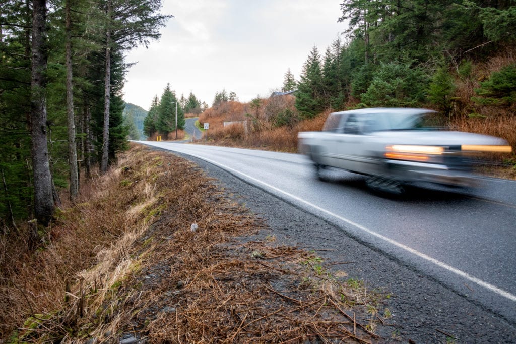
Residents and the DOT do agree on one point: that the pedestrian path is an absolute necessity. The gravel shoulder of Whitshed Road often narrows to mere inches, with speeding traffic on one side and a steep drop-off on the other.
“The bike trail is super necessary, I’ll grant them that,” Heidbrink said. “In summer, it’s busy. There are kids rushing back and forth to the trailer court. It’s a wonder that no one’s gotten run over yet.”
For safety reasons, the path will be either entirely lit or entirely unlit aside from some intersections. Partially lit paths are more dangerous because drivers’ eyes take time to readjust to darkness after passing through a lit area, Johnson said. Although the road won’t feature rumble strips, a concrete gutter will cue drivers that they’re wandering from the roadway. In some areas, railing will be used to make steep areas safer for pedestrians.
Preparation for the project will also include a geotechnical assessment of the area, to help design a stable retaining wall to run alongside the road. The project has hired a construction contractor to assist during the design process. This will help formulate more precise cost estimates, and work out the logistics of barging in construction materials, Johnson said.
But, before the earthmovers can be revved up and before the barges of concrete and asphalt arrive, there’s the matter of Mark Heidbrink’s pole barn, and all the other points at which private and public property clash. Heidbrink believes the DOT wants to resolve the situation without causing residents unnecessary aggravation, but remains uncertain whether this will actually be possible within the established rules.
“The DOT people were very friendly and nice,” Heidbrink said. “Kind of sheepish, because they knew they’d stuck a crooked stick inside a hornet’s nest and given it a good turn. At the end of it, I was saying, ‘Gosh, I’m glad I don’t have your job.’”


 268")