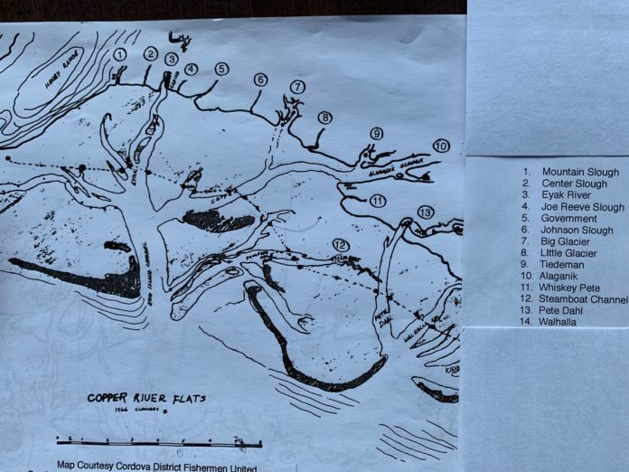
The names of sloughs and other key features of the Copper River Delta fall into four broad categories: names which contain Eyak, Chugach, and Ahtna roots such as Kokenhenic and Alaganik; geographic-based names, such as Mountain and Center Sloughs; activity-based names, such as Steamboat and Government; and names of fishermen who fished particular areas, such as Pete Dahl and Joe Reeve.
This is the first of a two-part series on the background of several places on the Delta traversing from west to east.
(Note: USGS is the abbreviation for the United States Geological Survey, DANP is the abbreviation for the Dictionary of Alaska Name Places, and Norman Swanson and Pete Lovseth were longtime Cordovans who I interviewed while researching this information.)
Mountain Slough: the name is geographic in origin, based on its proximity to the east side of Henry Range. It was reported as such in 1897 by Moser, commander of the U.S. Bureau of Fisheries steamer Albatross that did extensive research in the summers of 1897-1898, and 1900-1901. Crystal Falls Cannery was later located near a large waterfall a mile up the slough.
Center Slough: the name derives from its location midway between Mountain Slough and Eyak River. It was fished in the set/pole net era by N.P. Nelson, who later became a partner in the Crystal Falls Cannery. Crystal Falls Cannery was still operating in 1962. I was working for Alaska Department of Fish and Game doing salmon tagging studies that summer, and we used to run up to the small store there to purchase supplies.
Eyak River: Native name derived from the village and lake near it. According to DANP, a former Native village reported in 1869 as “Yhacks” by Maj. Gen. Halleck, U.S.A., also listed by Petraff in the 1880 Census as “Ihiak.” Population 94 in 1880, and 222 in 1900. Swanson mentioned that most of the numerous fisherman’s cabins at the mouth of the Eyak River used to be on the opposite (west) side of the river, since the water was deeper there due to the natural course of the river. The bank eroded, and in 1919, Parks Cannery set up a two-story rigging scow-cabin on the opposite bank; the others followed. The rigging scow was used for fuel and net storage, and is still standing. It is the only two-story cabin on the Delta.
Egg Island: is a 2.5-mile-long barrier island six miles southeast of Pt. Whitshed directly below the mouth of the Eyak River, it is a primary nesting area for Glaucous-winged seagulls and is site of egg gathering for subsistence. The local name was reported by G.D. Martin, USGS in 1905. (Note: The DANP lists a total of 18 Egg Islands scattered all over Alaska.)
Joe Reeve Slough: a small slough located between Eyak and Government, named after the set netter that utilized it from 1919 to 1922. Lovseth stated that Reeve was an old man at that time, single with no sons. He traveled Eyak River by rowboat and later by a skiff powered by a 7.5 Alto outboard. His small cabin site there was later acquired by legendary Cordovan Bob Korn, who expanded it into a popular duck cabin nicknamed the “Kornhole.”
Government Slough: named after a highly visible geodetic tripod that was located there to serve as a triangulation pointing in surveying the Flats. USGS also used Government Rock in the west near the mouth of Mountain Slough for this purpose. Swanson remembered the name was somehow connected with mapping; Lovseth remembered actually seeing the tripod, which “stood for years.”
Johnson Slough and Johnson Hole: Swanson indicated a fisherman named Oscar Oman had this site during the pole fishing era. Neither Swanson or Lovseth felt the name was related to any of the many local Johnson families.
Big Glacier and Little Glacier: geographic names, both are branches of water from Scott Glacier and named as Glacier in 1900 by USGS. Swanson indicated local fisherman made the distinction between the adjacent outflows based on the width of the sloughs out on the flats.
Tiedeman Slough: named after August Tiedeman, who originally reached this site by sailboat, living at Sheep Bay on Prince William Sound during the offseason and sailing around to set up his camp after the spring break up.
Alaganik Slough: a Native language name derived from the upstream village of Alaganik; reported by Moser in 1899. The DANP mentioned the village was visited by Russian explorer Serebrenikov in 1848; Lt. Henry Allen, U.S.A. stopped there on his historic 1885 exploration of the Copper River. Its population was 117 in 1880 and 48 in 1890. Because of the wide mouth of the slough, and its direct access to the main flow of the Copper River at Mile 27 on today’s Copper River Highway, many referred to Alaganik Slough as “the Copper.”


