In 1912 the U.S. Navy built a pair of 200-foot radio communication towers at a place named in various documents as Point Whitshed or Point Whiteshed.
Unfortunately, the location did not provide clear signals to a big naval base on Kodiak, and in 1917 new communication towers were built near Cordova along the CR&NW Railway. One was located at 7 Mile of the railway. Remains of buildings can still be seen there from the Copper Highway.
The layout of this station was described in great detail by Cathy Sherman in her recent Cordova Times series about naval communications.
The second station and tower were at 14 Mile. Recently the metal tower, which had collapsed and was laying on its side, and a large abandoned cement building, were demolished as part of the site clean-up.
The stations at 7 Mile and 14 Mile were connected by communication wire on a string of government telephone poles beside the railway right of way between the two sites. The poles were left standing through the 1950s along the gravel road that replaced the railway.
Later Naval reports contained confusion about whether the original site was Whitshed or Whiteshed.
No wonder.
Consider this amusing story about how the 7 and 14 Mile Sites were selected, from the Personal Recollections of Harold B. Phelps, Lt. (ret), published in Radio Stations Operations in Kodiak, Alaska.
“A crew had been instructed to concentrate on locating the stations along the Copper River railroad. They rented a speeder and cruised up and down the track for quite a few days. They couldn’t agree on the best location. One evening one of the engineers said ‘I’ve just received a message from the Navy. They told us to quit stalling around and locate these stations so construction could begin before winter sets in. Tomorrow morning I’m going to bring two quarts of whiskey to the speeder. When we leave town, we will start working on the first quart. Where we finish that quart will be the location of the first station. Where we finish the second quart will be the location of the second station.’”
Right. By then, who cared whether the original site was called “Whit-Shed” or “White-Shed” when they sent in their report to Navy headquarters.
Oh, by the way, recently the sign for the road has been changed from “Whitshed Road” to “Point Whitshed Road.”
Too bad the road doesn’t go there; it ends about three miles short. It would be a great place to sight-see, hike, bird watch, hunt, fish, cross-country ski, and even try to find a razor clam.
Although it would have been a good idea if the road didn’t go to the official Pt. Whitshed.
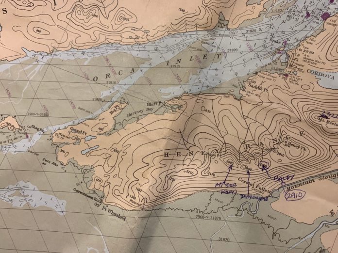
NOAA Chart #16709 Prince William Sound Eastern Entrance shows Pt. Whitshed over four miles to the east of the former location of the towers, identified with the circular symbol for a tower plus the letters “RTR” (i.e. Radio Tower).
The point named in honor of British Captain Whitshed in 1794 is actually a steep outcropping near Government Rock at the east end of Heney Range.
The white clam shacks were on the beaches near the towers and Shag Rock.
Which is commonly accepted by locals as Whiteshed. In fact, tenders taking deliveries of gillnet fish from across the Delta anchor there, and routinely report in as being located at “White Shed.”
So, my vote is for Whiteshed Road, not Point Whitshed Road.
With apologies to Captain Whitshed (RN).


